Monday, October 12, 2015

Antelope Canyon

Upper Antelope Canyon - September 30th

Antelope Canyon is near Page Arizona just over the Utah Arizona boarder.  Paige Arizona was a community that was developed while they were building the Glen Canyon Dam.  Paige has continued to be a thriving city.  

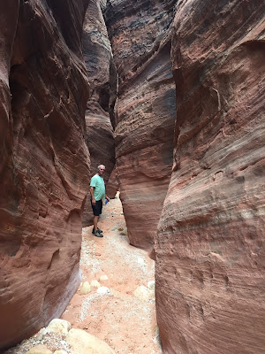
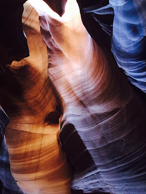
Antelope Canyon is on Navajo Reservation property and run by the native americans.  You will pay $8.00 per person to get to be on the reservation land and see the upper and lower Antelope Canyon's and to get to see the upper canyon you will need to pay $40.00 per person for a guided tour and then a tip at the end.  The groups go in 14 people per truck and there are a lot of tour groups going into the canyon.  It is BEAUTIFUL!  And very much worth it, but it is a quick and dirty tour you need to keep moving and there are lots of people.  We had a good tour guide who helped us know the best way to take the pictures the right angles, etc.  So, I think they turned out pretty good!  Also, he said that just one pictures from this canyon went for $6,500. These first two pictures are the entrance and the canyon is 135 feet from top to bottom. We did not go to the lower Antelope Canyon but it costs another $6.00 per person to go through that canyon.  Enjoy the pictures!  


Tuesday, September 22, 2015

Wire Slot Canyon

Canyons in Kanab Area

You may have heard of the Wave, which is a very unique canyon that looks like a great big wave.  To get to hike the Wave, you have to put your name into a lottery the morning before you want to hike.  The problem is, they only give out 10 spots per day and an average of 70-100 people show up for the lottery every day.  We tried a few times and didn't get a pass!  If you do get to hike the Wave, it is a 3.25 mile hike out to it and back!  And it isn't an easy hike.  This time of year it is very warm, mid 90's to 100 degrees, and it is over very up and down terrain.  The reason the Wave is on a lottery system is because it is on the "special" wilderness areas that they are trying to preserve and it is small, so if hundreds of people went there it would change the landscape.   
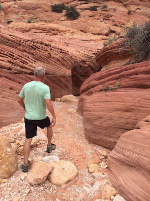
We did, however, go out to the area where the Wave is which is about 40 miles from Kanab and did some other hikes which were quite amazing, I think they were probably better!  We hiked the Wire Pass slot canyon which went out to the Buckskin Gulch.  The canyons were at least 100 feet tall in places.  After we got back from our hike, we found out that the river we came upon (so we couldn't go any further), was actually a flash flood.  Glad we found out after we got back!

This is the "nice" road out to the Wave and Buckskin Gulch!  We had to go through a river to get to the trailhead of the hike.  There were a few cars that were stuck on the other side of the river and didn't want to cross, but after they saw John cross, they went ahead and did it. Nobody got stuck, but one of the cars had to make about 4 passes at it to get across.

Here is a map of where we went.  We took the 89 East to the 700 and then went south to Wire pass and walked in.  probably round trip we went 4+ miles.  


 Some of the slot canyons were pretty narrow, you would touch both sides of the canyon at the same time!


Zion National Park and a little shooting practice!

Zion National Park

We have driven through Zion a couple of times, but haven't stopped to do any hikes yet.  You may have heard on the news that there was some really bad rains here and that 7 hikers were swept away in a flash flood in one of the Zion Canyons.  We are waiting for the trails to be reopened and cleaned up before we try any of the hikes.  The pictures at the end are showing how much water there was after the heavy rains.  There were waterfalls where there isn't normally a waterfall. 

It was also interesting to me that in the park the roads are red.  I guess they use the red rock to pave them.  And, in the middle of the park is a 1.1 mile tunnel right through the middle of the park's BIG rocks!  Quite amazing, I don't know how long it took them to do that, but it was a very long tunnel.  They had 3 openings along the way so you could look out, and I'm sure get some airflow through the tunnel.  It was very dark in there!  

Here are some pictures from our drive through the park.  It is a beautiful park and we can't wait to explore it more.  We will post more pictures when we have them.


We were right up against the rocks, glad we weren't in the motorhome.
Having a great time riding the motorcycle through the parks, so fun to see up close!


So close to the rocks!  Sure glad we weren't doing this in the motorhome!


This is the beginning of the 1.1 mile long tunnel, you can barely see the opening.


After the tunnel, we started a zig-zag down into the floor of the canyon.


This picture is the floor of the canyon after the heavy rains,  They were worried it would erode the road away where it is getting close in the middle of the picture.
There isn't usually waterfall here, this is just after the heavy rains.
In Utah when it rains, it creates flash floods that cannot be anticipated.  They come up so fast you can't get away from them, so when it rains, you have to be extra careful of going into canyons.

This is the creek after the heavy rains, way higher than normal!


On a slow day, we decided to go out to the shooting range and do a little target practice.  It was fun!  I didn't do too bad for a first timer,  but the closer I got the better shot I was!  LOL.  If we are going to have guns, it's a good thing to become familiar with them and feel comfortable handling them.   John shot the 357 and the 9mm, I only shot the 9mm.